201732 Threading the needle - then grounded
Edited from official TSB Canada report M15C0006
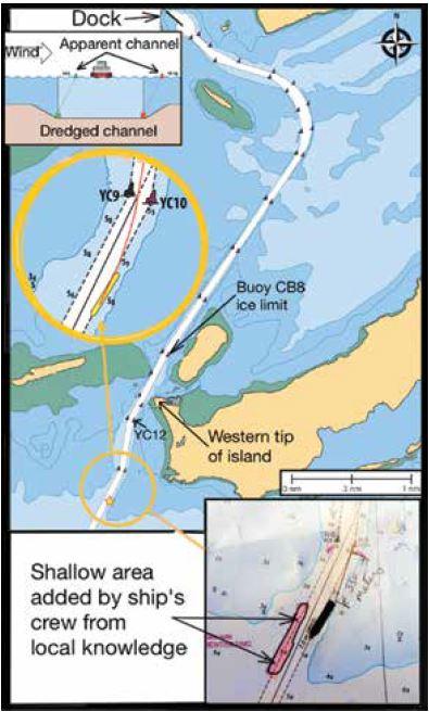
A bulk carrier was inbound to load in a very restricted waterway under self pilotage, as is the practice at this port. The Master was informed of the relevant local knowledge, and the shallow area within the channel between buoys YC5 and YC9 was added to the vessel’s chart. On the inbound voyage winds were northwest at 35 knots and blowing snow reduced visibility. The inner portion of the channel was ice covered, which helped limit the set of the vessel due to wind. A tug met the vessel at the outermost buoys and the vessel followed the tug inbound through the channel. Loading was commenced immediately after docking.
Once loaded, the bulk carrier proceeded outbound at a speed of five knots, following the tug and the track through the ice-covered water. The wind was now from the west-northwest at 25 knots, gusting to 30 knots, and visibility was good. The officer of the watch (OOW), the Master and a helmsman were on the bridge. The Master was standing at the centre console and monitoring the vessel’s progress visually using the buoys. From the centre console, an electronic chart repeater monitor was visible to the Master which he used as a check. The OOW was monitoring the vessel’s progress on the port radar using parallel indexing while also monitoring the buoys on either side of the vessel as they passed.
In the vicinity of buoy CB8, the bulk carrier exited the ice and entered open water, while the tug turned back toward the dock. The bulk carrier’s speed was now seven knots. Upon passing the western tip of the island, the OOW ceased parallel indexing as there were no prominent features to use. The Master continued to navigate visually using the buoys, and the OOW was asked to assist by monitoring each buoy as it approached and giving a distance off and all clear once the vessel had passed it.
A few minutes later the Master advised the OOW that the electronic chart was indicating that the vessel was outside the channel. After checking the depth sounder, which indicated 0.7 metres beneath the keel, and visually verifying that the vessel was aligned between the next set of buoys, YC11 and YC12, it was concluded that the electronic chart was not displaying the vessel’s position accurately. No further verification of the electronic chart was made at this time, nor was the vessel’s position plotted on the chart.
At buoys YC11 and YC12, the Master completed a course alteration to port, bringing the vessel onto a course of 189°. To compensate for the winds, the vessel’s heading was 195°, with a course made good of 189°. In preparation for the upcoming alteration to starboard, the Master closed the buoys on the starboard side in order to maximise sea room on the port side and account for the set to port. The turn was to be initiated once the vessel was approximately 1.5 ship lengths from buoys YC9 and YC10. A few minutes later the electronic chart displayed the vessel’s position as re-entering the navigation channel. To determine the wheelover point for the upcoming starboard turn, the Master then estimated the distance back from the buoys visually, and verified it by using the electronic chart to estimate the distance back from the buoys relative to the length of the vessel icon displayed on the electronic chart screen. The Master gave a helm order of 10 degrees to starboard to make the new course of 207°. After approximately 20 seconds, there was no change in the vessel’s heading, so the Master ordered 20 degrees to starboard, followed very closely by hard to starboard. The Master also increased the telegraph to full ahead to assist the vessel in turning. As the vessel began to turn to starboard, the Master asked the OOW to watch buoy YC10 on the port side and advise of its distance off as the vessel passed. When buoy YC10 passed amidships, the rudder was returned to amidships to slow the turn to starboard and settle up on the next course, which was marked by a set of ranges. Once the vessel was past and clear of buoy YC10, the OOW advised the Master. The Master now determined that the vessel was on the port side of the channel and setting further in that direction. The ranges marking this leg of the channel, which were located astern of the vessel, were not referenced. The Master ordered the helmsman to apply starboard helm and soon the bulk carrier’s rate of turn began to increase. Approximately 15 seconds later, the vessel made contact with the bank southeast of the buoyed navigation channel at a speed of 7.5 knots. The rate of turn and the vessel’s speed began to reduce and then the vessel grounded just outside the navigation channel about 1.5 ship lengths away from buoy YC10.
- The buoys were being set off their charted positions by the prevailing wind and current. By using these buoys as the primary method for navigating, the bridge team lost awareness of the vessel’s actual position within the channel.
- The vessel was using an outdated electronic chart, which no longer displayed the channel or buoy positions accurately. Using this to verify the wheel-over position probably led the Master to initiate the turn later than intended.
- The bridge team did not use all available navigational equipment to verify and monitor the vessel’s position, limiting their ability to identify human or equipment errors.
- Although a passage plan had been developed, it was missing certain information (wheel-over positions, frequency of position fixing). Despite the complexity of navigation in the channel, the passage plan contained the same degree of detail as when the vessel was sailing in open water.
- Several steps to ensure safe navigation had not been taken, despite being marked as complete on the passage planning checklist (eg ensuring the electronic chart was up to date, inserting wheel-over points and parallel index data on the chart).